10 lovely spots within a 10 minute drive
Apart from the main sights and centres in the area we have some smaller gems for you to visit all within a 10 minute drive:
 Pont y Cim is an historic stone bridge in the village of Pontllyfni. One wet and stormy night in 1612 a young man drowned trying to cross the original ford in the river to visit his girlfriend, Catherine Buckley of the nearby Glynllifon Estate. In memory of him she ordered the building of the bridge. An inscribed stone on the bridge reads “Pont Y Cim, Catring Bwkle hath give 20 povends to mack this brighe.1612” . Measuring only 6′ 6″ (1.9m) wide it is claimed to be the narrowest road bridge open to road traffic in Wales, maybe the UK (unless of course you know differently!)
  On the northern end of the beach at Aberdesach is a large stone cael Maen Dylan. It is named after a character from Wales’ oldest stories and legends.Maen Dylan is the reputed location associated to the tales of Dylan ap Don and Govannon. Together they forged the three-pointed spear which when tested in battle took the life of Dylan ap Don. On the other hand the ancient Welsh legends, Y Mabinogion states that Dylan is the son of Arainrhod and it’s here that Dylan plunges into the sea and become ‘one’ within the aquatic world. The stone is situated along the shoreline at where it can be reached when the tide is half way out. It is in an easterly direction of the reef known as Caer Arainrhod, within Caernarfon Bay. [Photo: John Stephen]
 St Beuno’s Church in Clynnog Fawr is dedicated to Beunowho became an active missionary and was awarded the township of Clynnog Fawr where he founded his church in the early 7th century. The church mostly dates from the late 15th and early 16th centuries. In medieval times the church was an important stopping place for pilgrims heading for Bardsey Island. To this day important artefacts are to be found at St Beuno’s Church including an ancient wooden chest hollowed out of a single piece of ash (Cyff Beuno), and used to keep alms donated by the pilgrims (nothing changes). A stone known as Beuno’s Stone (Maen Beuno) has markings reputed to be those of Beuno’s fingers and outside in the churchyard there is a sundial dated between the late 10th century and the early 12th century.
 The closest mountain to Bryn Eisteddfod is Bwlch Mawr which offers possibly the best views in the area. It can be reached within a few minutes in the carand then a treck to the summit might take around 1.5 hours but is well worth it. The summit has panoramic views of Snowdonia, the far hills of Anglesey, the island of Holyead, Caernarfon Bay and the whole of the Llŷn peninsula as well as views of the mountains o Meirionnydd. On clear days the Wicklow mountains in Ireland can be easily seen. This is not a mountain that’s on the tourist trail so it is highly likely that you would have the mountain to yourself!
 Dating back to the Neolithic period (4,000-2,000 years BC), the Bach Wen cromlech, accessed by a public footpath from Clynnog Church, and only 10 minutes walk from Bryn Eisteddfod, is beautiful positioned between the hills and the sea. The spot has stunning views of Caernarfon bay towards Anglesey as well as down the coast towards Y Eifl mountains and the coast of the Llŷn peninsula. The chamber is 1.8m by 1.0m and is defined by four upright stones supporting a capstone, 2.75m by 1.6m. The structure being around 1.8m in height overall.
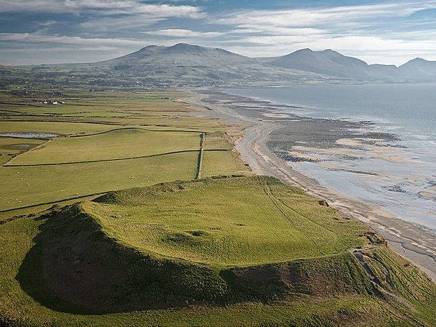 Dinas Dinlle coastal hillfort is owned by the National Trust. It is set on a hill overlooking the sea and Caernarfonshire coastal plain. The hillfort and Second World War seagull trench on the northern slopes of the fort are protected as Scheduled Monuments by Cadw and the hill is a Site of Special Scientific Interest (SSSI). It is thought to be later prehistoric (Iron Age) in date but chance finds of Roman coins, a carved gemstone worn in a ring representing Victory with a trophy and pottery suggest occupation in the Roman period. There is a possibility that the prominent, squarish stone mound inside the fort could be a Roman lighthouse? Dinas Dinlle takes its name from one of the Welsh legends of Y Mabinogi and the story of Math mab Mathonwy and Lleu Llaw Gyffes, who gave his name to the hillfort Dinlle (‘din’ in old Welsh meaning fort + ‘lle’ short for Lleu).
 Located just off the main A499 road the village of Trefor has a small harbour and a small sandy beach. Fishing boats are moored in the sheltered harbour and the beach is a very safe place for the kids to play. Overlooking the village is the quarry of Trefor where granite was extensively mined. It is from here that the granite ‘sets’ for the streets of Liverpool were sourced. The local stone is still used for makinf the stones used in the Olympic sport of Curling. The village has a circular walking route that takes you passes Trwyn Y Tal stacks (see below) and along the base of the quarry. The imposing three peaks of Yr Eifl mountains are a stunning backdrop to this traditional Welsh village.
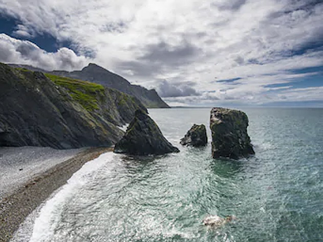 These large stacks of rocks in the sea just to the south west of the village of Trefor are a wonderful sigh to see. Around them you may see seals and dolphins as well as harbour porpoises. The stacks can be seen from the Wales Coast path that passes right by them. park at Trefor beach and walk along the headland.
This photo shows Trwyn-y-Tal with Trwyn-y-Gorlech in the background, where the quarried mountain at nant Gwrtheyrn called Mynydd Gwaith descends sharply to the Irish Sea.
 Dinas Dinlle has a large sand and pebble beach with vast areas of sand from mid-tide level. The foreshore consists of natural pebble banks. The popular beach offers views towards the Llŷn Peninsula (Penrhyn Llŷn) and towards Ynys Llanddwyn (Llanddwyn Island) on Anglesey. The area is a designated Site of Special Scientific Interest (SSSI). The cliff above the beach is known as Boncan Dinas and is occupied by an Iron Age hillfort (see above). At the northern end of the beach is a small airport, Caernarfon Airport. During the Second World War this was an RAF base but now it is mainly used for flying lessons and pleasure flights. There is ample parking very close to the beach as well as an area of the beach that has a designated a dog-walking area.
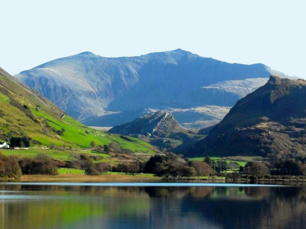 Llyn Nantlle is a natural lake located in the Nantlle valley known for its slate industry. There were originally two lakes but the lower lake was drained to protect the nearby slate workings. It is one of the few lakes in Wales where you can obtain access to fish for salmon and sea trout from a boat, being also a great wild brown trout fishery. From the north west side of the lake Snowdon and its summit can be viewed. The lake forms the foreground in Richard Wilson’s 1765 painting “Snowdon from Llyn Nantlle”